

MAPS
Laying out my adventure’s landscape

I have considered illustrations for my post-apocalypse science fiction novel, Power of the Ancients, since I began working on it over ten years ago. I self-published the novel in 2021, but without illustrations or maps, though I wanted to include both. I felt like the world I was imagining would be better understood by readers if they had visuals to go along with the text. When I completed the novel’s writing, after some editing and beta-reading, I did not wait to come up-to-speed on illustrating, I published it as I had it.
Now, well into drafting the second novel of the trilogy, I want to revamp the first novel and add maps and at least one illustration. I certainly cannot pay for it, so I have to do it myself. I was a decent artist in my youth.
A couple of years ago, I jumped into trying to regain my sketching skills by following an art instruction book, You Can Draw in 30 Days by Mark Kistler. Following the lessons in the book, I surprised myself at how much decent drawing I was able to do.

Though I got back into drawing, somewhat, I did not tackle any illustrations for my novel until recently. I reread Power of the Ancients and updated my manuscript from the effort, fixing a lot of errors and things I just didn’t like. With the text revised, I decided to add the maps I’ve always wanted.
So I watched some YouTube videos on drawing fantasy maps (there were a lot of these, many focusing on drawing maps for use in playing Dungeons & Dragons). I was inspired, which led to my drawing the three maps I felt were essential for aiding readers in following my novel’s narrative.
Firstly, I wanted to show the North American continent in the grips of a new ice age. So I created a map of North America with the northern half buried under ice. The southern part is where people survived and reformed society. They call this, the only land they know, The Southland. It is the US from east to west coast, with an expanded coastline because much of the world’s ocean has again been displaced by ice. The whole of my Dentville saga’s action will occur in this strip of habitable land.

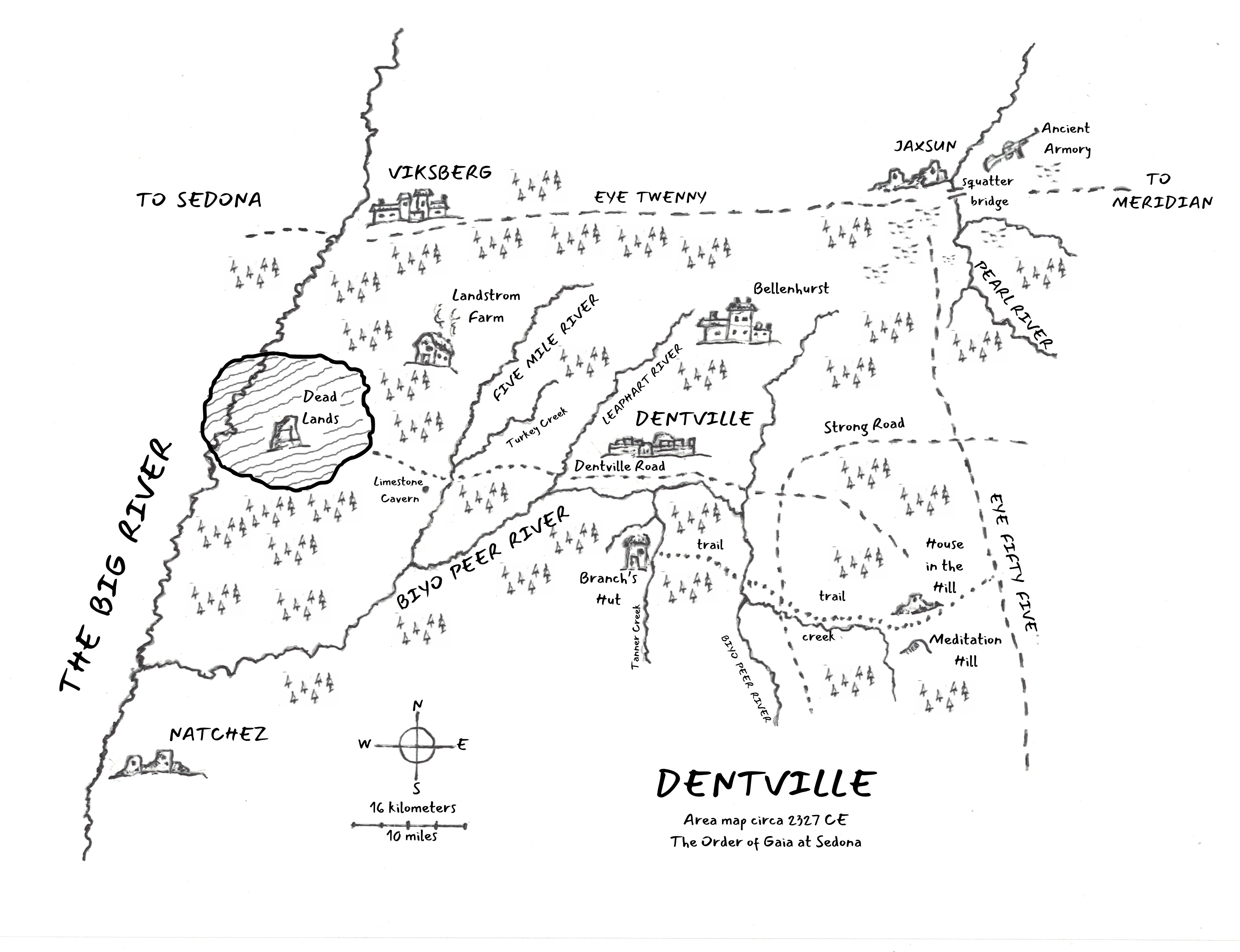
Then I wanted to focus on the city of Dentville and its surroundings in Southland. I wanted to show Dentville and the locations around it that will be important for the story. Mostly, this will be the ruined city of Jaxsun and the lands between it and Dentville. The important places I mention in the book are noted on this map.
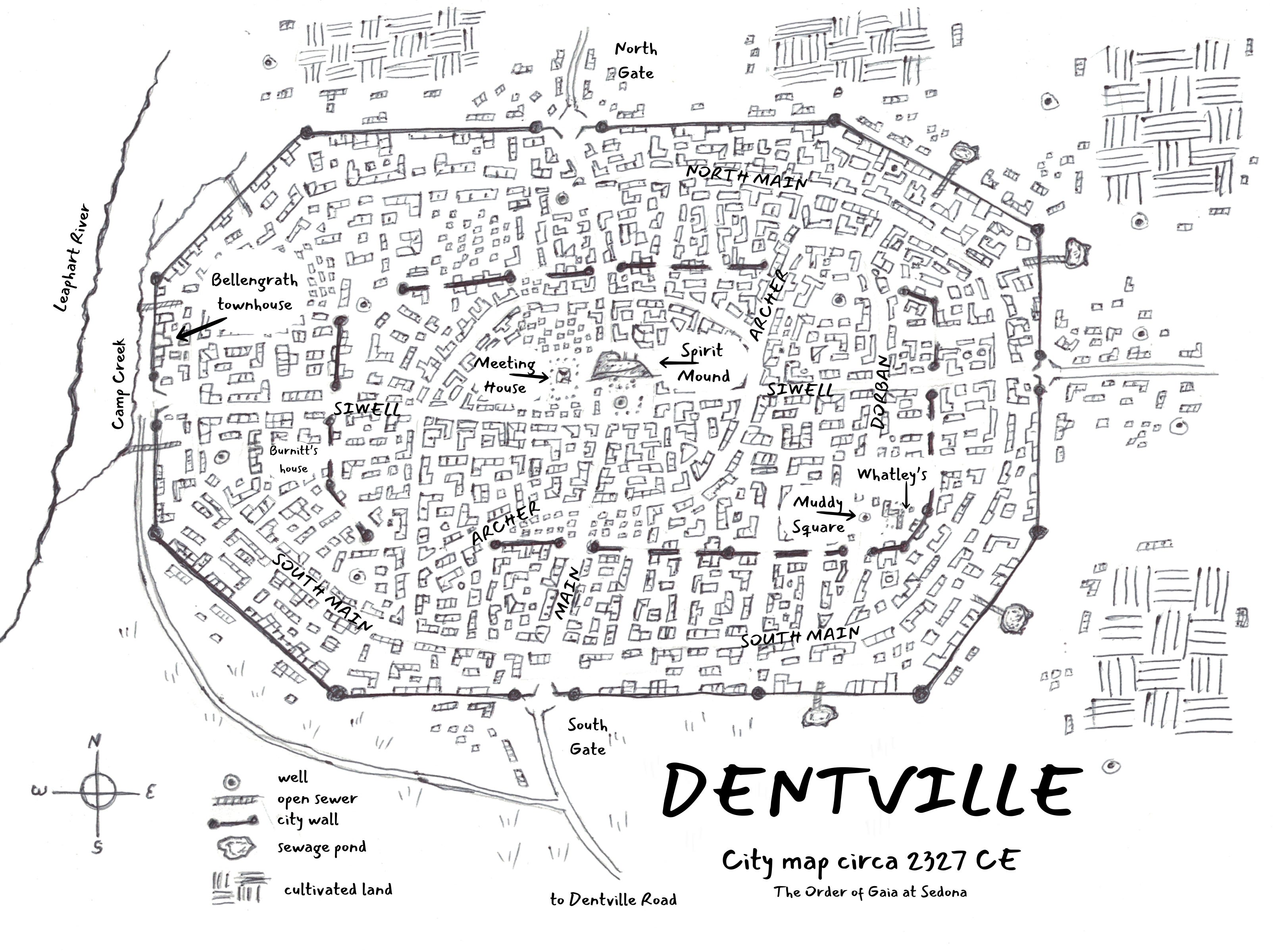
My biggest map challenge was the city of Dentville itself. I thought for a long while on how to depict the city. I had an idea of it in mind and followed that mental image as I drafted the first novel. But I needed something concrete for the following novels and for readers to follow. Again, I consulted YouTube videos, pulling especially from those artists making D&D cities. Their inspiration seemed to be a medieval map of Frankfurt, Germany, and it became my inspiration as well. After video views and practice sketches, I came up with a city map that seemed reasonable. I hope it will help readers.
It is very helpful, I think, to sketch out maps of the areas important to a fantasy story. I wish I had done that early in my story-writing work. It would have helped the writing process very much. As it is, I have created maps that I believe are suitable as aids for my Dentville series books.
My intention is to use my updated Power of the Ancients manuscript and the maps to create a hard cover edition of the novel. Amazon allows that now, so I will take advantage of their provision. I expect to do this in January. I’ll let you know when it’s available (the paperback and Kindle editions will also be updated), and I hope you’ll be inspired to buy a copy. I may even come up with some kind of give-away.