

RAY’S WORLD WEATHER REPORT FOR 11/20 TO 12/12/2023
INTENSE WINTER STORMS, GEOENGINEERING HORRORS, MAJOR FLOODING IN EUROPE, MAJOR VOLCANO, EARTHQUAKE SWARMS, 16 DAY FORECAST: US SNOW AND STORMS . --REPORT DATE: 11/26/2023

Intense storms struck around the world bringing severe flooding to many areas. Winter storms are also getting intense in the US and Europe. Geoengineering (spraying) has been intense over the US, reaching levels of sheer horror in the South by Saturday (11/25). The sun has blasted out some CMEs and strong solar winds, creating geomagnetic storms and strong auroras. Some strong earthquakes struck around Indonesia and a major volcano eruption hit Papua New Guinea.
ACTIVE STORMS: Only one significant cyclonic storm in the world. It began as invest 94P on Tuesday (11/21), meandering in the East Pacific southwest of Mexico. It developed into a tropical depression TWENTY-E on Friday and then became Tropical Storm RAMON on Saturday. It is forecast to loop-the-loop were it is and then dissipate without a landfall.
There were some heavy non-cyclonic, though severe, storms around the world. One in Turkey killed nine people and sunk a cargo ship.
A tropical disturbance hit the Dominican Republic bringing devastating floods. Another storm brought record flooding to Porto Alegre, Brazil. Torrential rains in the Congo brought them severe flooding, displacing thousands of people.
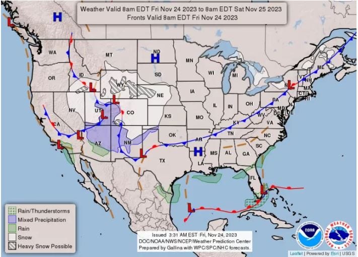
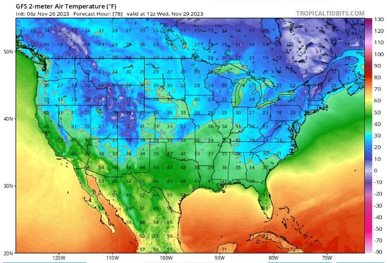
A winter storm covered the US Rockies region and the Great Plains all week with snow and freezing temperatures.
A severe winter storm is forecast to blast eastern Europe with Arctic conditions.
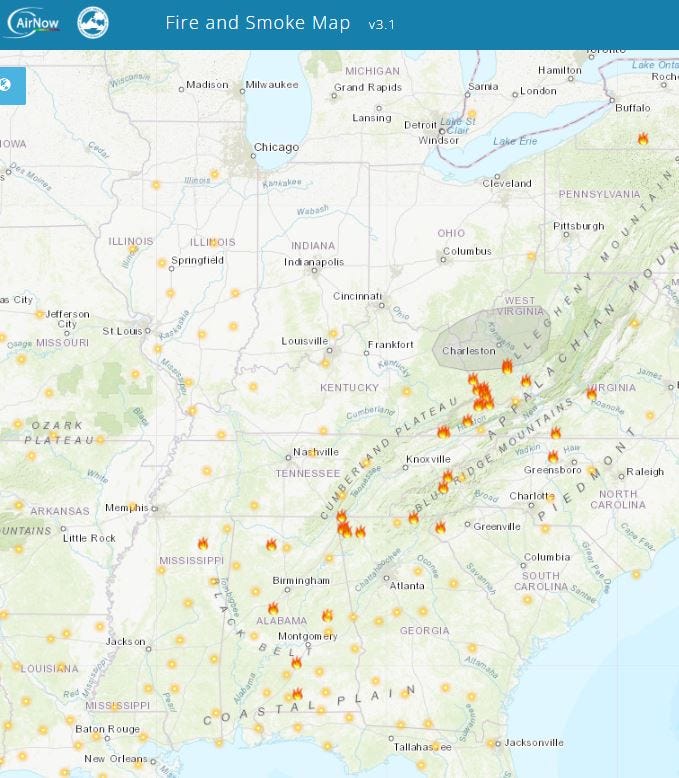
WILDFIRES: The week began with some intense fires in Virginia. That died out by Monday. The most persistent wildfires I see on the maps stretch in the US from Alabama up the Appalachians to West Virginia, where the most smoke is accumulating at this time.
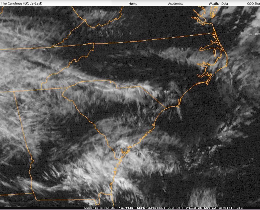
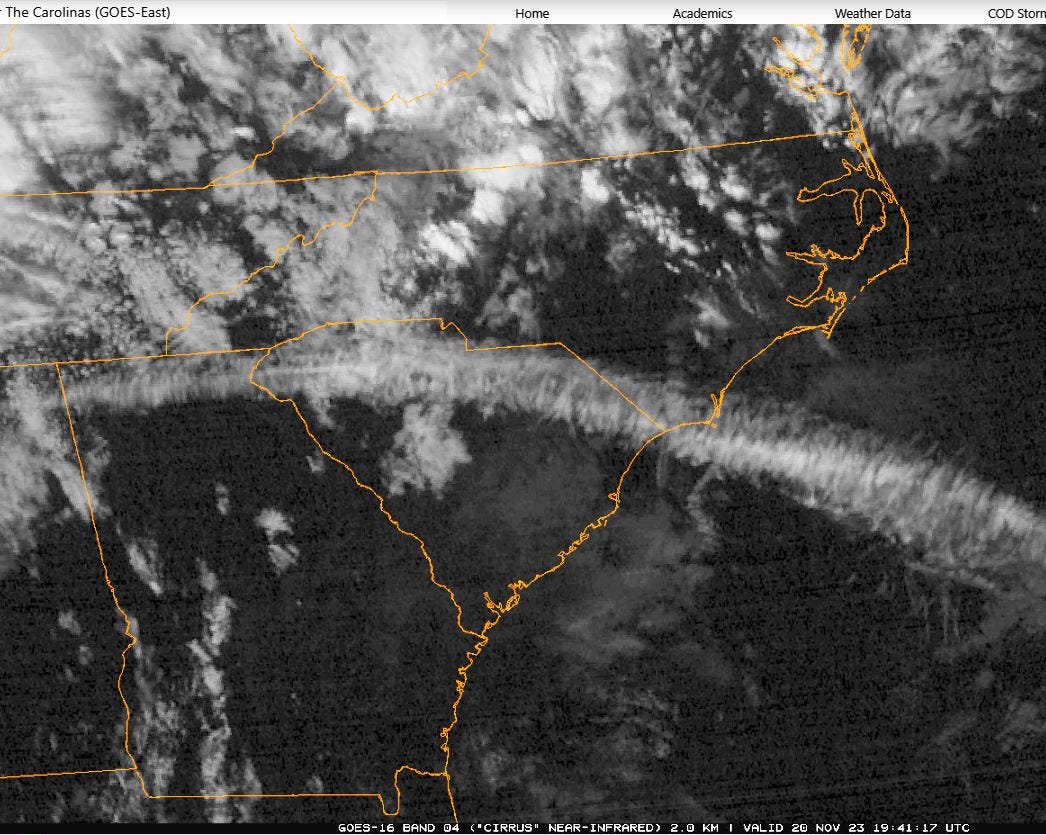
GEOENGINEERING: Spraying was intense across the US all week. On Monday (11/20) the GOES-East satellite showed a “streamer” across the South from Texas to South Carolina. It looked like a giant spraying trail. Spraying even extended into the Atlantic and inundating Bermuda. The spraying across the South by Saturday (11/35) was horrific. I saw it from the ground in South Carolina and the sight was sickening.
PRECIP TARGET ZONES (NEXT SIXTEEN DAYS):
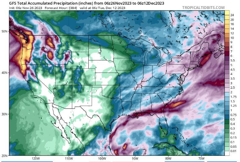
Heaviest precipitation comes out of the gulf stretching across the southern coast, over northern Florida and out to sea. Even heavier precipitation will hit the Northwest from Washington state, down the coast to northern California.
FORECAST (NEXT SIXTEEN DAYS to 12/12/2023):
We start with very cold air over the West and Rockies held by High pressure. The winter storm is moving east with snow in the Midwest. Thunderstorm cells have developed just off the gulf coast and over New Orleans. All this weather will move east, bringing much snow and cold temps to the North and Northeast. Rain will move across the South and it will all be out to sea by 11/28.
Precipitation will clear out but cold air will descend over the US into the West and as far south as the Carolinas.
The cold will gradually ease north, but remaining over the West and Northeast as a storm system develops over the Midwest centered over Illinois and Tennessee by 12/01. This system will move east fast and out to sea in a day.
More snow with high winds will develop in the West by 12/04, as storms move into the Northwest from the Pacific. An intense storm system will develop out of the South and move into the Northeast, getting really over Pennsylvania and New York. This storm will move Northeast, bringing heavy snow to Maine before moving out to sea by 12/06.
Another heavy storm will develop over Alabama by 12/09 as part of a system with cells stretching north to Canada. This will move east, dumping much rain on the eastern seaboard, especially in the Carolinas. It will move offshore by 12/10 with cold air moving in behind it. This system spins into a very intense storm that strikes the Northeast over Maine and New Brunswick, dumping up to six inches of snow in 24 hours.
By 12/12, the Northeast snows will be much lighter and most of the US will be clear and a bit warmer. More snow will be moving into the Northwest but the severe cold will have retreated to the US/Canada border.
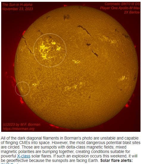
SPACE WEATHER: The sun has been pretty quiet for the last couple of weeks, but it came back to life by Tuesday (11/21). The average number of sunspots broke 100, reaching 184 by Saturday (11/25). The solar wind has also been strong, breaking 500 km/sec on Wednesday and Saturday. The sunspots are active along with other regions and have been flaring out CMEs and prompting a geomagnetic storm alert, which is still in effect (11/25). The wind density has been in the double digits protons/cm3, and a geomagnetic storm of G2 strength was recorded for Saturday.
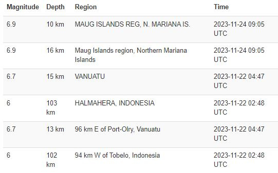
EARTHQUAKES: Quakes have swarmed and been intense around Indonesia and Guam this week. M6.9 quakes struck in the Maug Islands region near Guam. A couple of M6.7 quakes struck near Vanuatu (between the Solomon Islands and New Caledonia) on 11/22.
VOLCANOES: As reported by THE WATCHERS: On Monday, November 20, 2023, at approximately 15:30 local time (06:30 UTC), Papua New Guinea’s Ulawun volcano erupted violently, sending volcanic ash as high as 15.2 km (50 000 feet) above sea level.
Magma is still moving in Iceland near Grindavik, though eruption likelihood is lessened.
New activity/unrest was reported for 1 volcano from November 8 to 14, 2023. During the same period, ongoing activity was reported for 18 volcanoes. New activity/unrest: Reykjanes, Reykjanes Peninsula.